Open Menu
US
World
Politics
Business
More
Opinion
Health
Entertainment
Style
Travel
Sports
Videos
Listen
Search CNN
Search
Listen
Edition
US
International
Arabic
Español
Edition
US
International
Arabic
Español
US
Crime + Justice
Energy + Environment
Extreme Weather
Space + Science
World
Africa
Americas
Asia
Australia
China
Europe
India
Middle East
United Kingdom
Politics
SCOTUS
Congress
Facts First
2024 Election
Business
Tech
Media
Success
Perspectives
Videos
Markets
Pre-markets
After-Hours
Market Movers
Fear & Greed
World Markets
Investing
Markets Now
Before the Bell
Nightcap
Opinion
Political Op-Eds
Social Commentary
Health
Life, But Better
Fitness
Food
Sleep
Mindfulness
Relationships
Entertainment
Movies
Television
Celebrity
Tech
Innovate
Gadget
Foreseeable Future
Mission: Ahead
Upstarts
Work Transformed
Innovative Cities
Style
Arts
Design
Fashion
Architecture
Luxury
Beauty
Video
Travel
Destinations
Food and Drink
Stay
News
Videos
Sports
Pro Football
College Football
Basketball
Baseball
Soccer
Olympics
Hockey
Videos
Live TV
CNN Headlines
CNN Shorts
Shows A-Z
CNN10
CNN Max
Audio
CNN Underscored
Electronics
Fashion
Beauty
Health & Fitness
Home
Reviews
Deals
Money
Gifts
Travel
Outdoors
Pets
CNN Store
Coupons
Weather
Climate
Storm Tracker
Wildfire Tracker
Video
About CNN
Photos
Investigations
CNN Profiles
CNN Leadership
CNN Newsletters
Work for CNN
Follow CNN
JUST WATCHED
A prepararse para más tormentas tropicales este año
Replay
More Videos ...
MUST WATCH
A prepararse para más tormentas tropicales este año
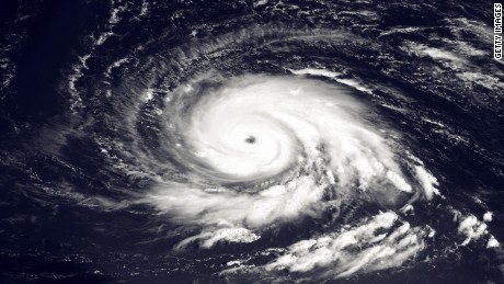
Este 2017 parece registrar una mayor actividad ciclónica en el Atlántico: ya hay dos tormentas en junio, algo que no ocurría desde hace 50 años.
Source: CNN
Stories worth watching (15 Videos)
A prepararse para más tormentas tropicales este año
Survivalist shares how coconuts helped stranded fishermen survive on Pacific island
Charles Barkley teases staff as 'King Charles' hosts wrap up season
Fareed: How Trump and Biden hiked up inflation
Watch zoo animals react as totality passes over Texas during eclipse
Pregnant woman's Ring cam messages to neighbor go viral
When a race is also Dubai's most iconic fashion event
Why Black patients were kept off kidney transplant list
Ne-Yo on AI impact on music: 'How is it creative to mimic me?'
'This happened all the time': Wrongfully convicted man speaks about his case
Reporter explains why many Americans suddenly stopped hanging out with friends
Legendary rocker performs song written for journalist murdered by ISIS
'John Wayne-style takedown': Bodycam footage captures unusual police chase
Man drove over bridge moments before collapse
'It is my dream': woman says she risked it all for gender affirming surgery in Thailand
Here's when a social psychologist recommends letting your child use smartphones and social media
See More
A prepararse para más tormentas tropicales este año
Este 2017 parece registrar una mayor actividad ciclónica en el Atlántico: ya hay dos tormentas en junio, algo que no ocurría desde hace 50 años.
Source: CNN