


Editor’s Note: A version of this article originally appeared in the weekly weather newsletter, the CNN Weather Brief, which is released every Monday. You can sign up here to receive them every week and during significant storms.
The coldest air of the season – by far – will dive down from Canada, bringing dangerously cold temperatures to millions this week. Temperatures will drop so low in some places that frostbite could begin in as little as five minutes on exposed skin.
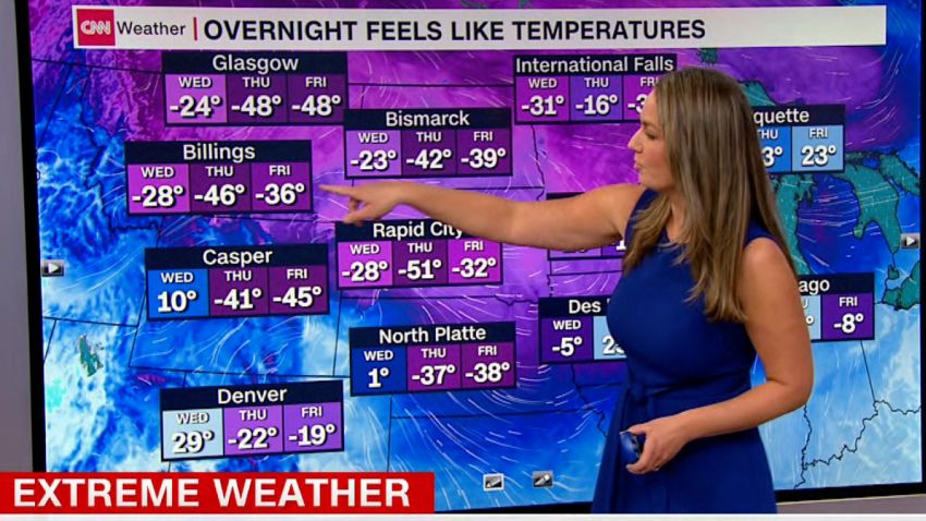
Temperatures are already cold to start the week across much of the northern tier of the country.
“Highs over central and eastern Montana will struggle to get above zero today, while daytime lows ranging from 0 to -15 degrees will be common from eastern Washington to the Upper Mississippi Valley,” the Weather Prediction Center wrote.
But this is only the beginning of a brutal week that will get much, much colder – as temperatures dive 30 to 50 degrees below normal.
“Daytime lows on Tuesday dip as low as -20 to -30 in parts of Montana, with sub-zero lows bleeding more into the central High Plains,” the prediction center said. “Blustery winds throughout the region are responsible for bone-chilling wind chills, ranging as cold as -30 to even -60 degrees.”
This week, more than 80% of the Lower 48 will experience temperatures below freezing. Places as far south as Houston; Austin, Texas; Atlanta and even Orlando are currently included on that list. And some in the Midwest could also experience their coldest Christmas Day in nearly 40 years.
A holiday storm set to impact millions
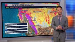
The cold air will allow for a major winter storm to develop, bringing significant impacts to the central and eastern US which could wreck any holiday travel plans this week.
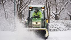
This big winter storm will take shape beginning on Tuesday, bringing heavy snow, strong winds – both of which could lead to blizzard conditions – rain, and even colder temperatures to follow.
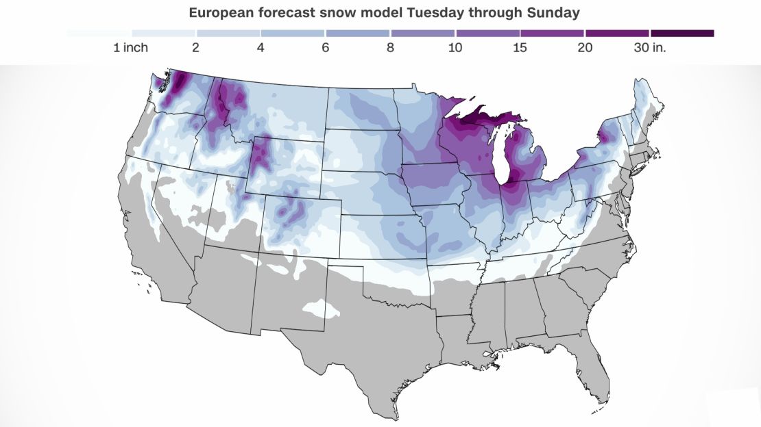
The snow will begin across the Rockies and amplify as it approaches the Midwest, where the biggest impacts from the storm will be felt. Snow will begin for this region Thursday evening and last through much of the Christmas weekend.
Heavy snow will fall across much of the Midwest and extend as far south as the Lower Mississippi Valley – where we could see snow flurries as far south as Jackson, Mississippi.
Chicago will be one of the cities hit the hardest, as its National Weather Service office warns of the potential for a blizzard.
Blizzard conditions occur when there is falling or blowing snow combined with winds of at least 35 mph leading to reduced visibility to at least a quarter of a mile for at least three hours.
“Rapidly deteriorating conditions by late Thursday afternoon, with dangerous blizzard conditions appearing increasingly likely Thursday night into Friday,” said the weather service office in Chicago.
This will bring holiday travel to a standstill. The weather service is already urging people to make alternate plans for travel.
According to one forecast model, we could see more than a foot of snow pile up across the Midwest.
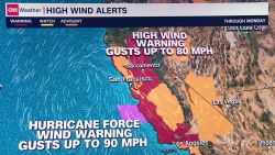
Power outages will also be a concern for the Windy City as winds could gust as high as 50 mph on Friday. This will only exacerbate the storm’s impacts as wind chills will drop to at least 20 degrees below zero, possibly even colder.
The expected high on Christmas Day in Chicago is 12. That would make it the coldest Christmas in Chicago since 1996. A little farther south, Indianapolis has a forecast high of 13 degrees, which could be their coldest Christmas since 1985 – nearly 40 years!
The reason for the cold is a major dip in the jet stream, that’s allowing for super cold air to dive very far south.
“It’s night in the northern hemisphere Arctic regions and there’s snow and ice covering that entire area. So, you’ve basically got a source freezer sitting up there in the Arctic polar regions,” Greg Carbin, branch chief at the prediction center said. “It’s sort of the Polar Express and the cold air can hold on to those characteristics because there’s a lot of snow cover on the ground, even across the north-central United States.”
Minneapolis is expected to drop below zero on Wednesday afternoon and may not get back above zero until Saturday – a full 72 hours later.
Parts of central Minnesota could see “several inches of fluffy snow” that will continue into Wednesday night, the National Weather Service office in Twin Cities said on Facebook. By Thursday, wind gusts in the area will reach up to 40 to 50 mph.
“The bottom line is travel will be very dangerous and could be LIFE-THREATENING later this week so be prepared to alter travel plans now!” the weather service said.
Fargo, North Dakota, will drop below zero this evening and not get above zero again until Christmas Day.
Wind chill alerts stretch across much of Montana, the Dakotas, portions of Minnesota and Nebraska where wind chills could drop as low as 60 degrees below zero.
This extreme cold will dive to the Deep South as well. Places including Atlanta could experience one of their top three coldest Christmases, with the high expected to only reach 33 degrees.
Nashville and Memphis, Tennessee, will also drop below freezing on Friday. Nashville will reach only 16 on Friday with 25 mph winds making it feel like 3 degrees below zero. They will hit only 26 on Christmas Day. Memphis could see its coldest Christmas since 1985 with a forecast high of 28.
Places including Little Rock, Arkansas, and Oklahoma City could also struggle to get above freezing on Christmas Day.
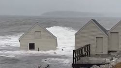
A bomb cyclone for the Northeast
The storm will bomb out Friday night into Saturday morning, making this a bomb cyclone before entering the Northeast and New England. A bomb cyclone is when the storm drops 24 millibars in pressure in 24 hours.
Watch: What is a bomb cyclone?
The storm will bring mainly rain to the I-95 corridor, except for maybe a brief window of some heavy, wet snow on Friday night. Much of this area will experience miserable, cold, windy rain.
“I-95 gets a slug of pretty deep rain and that can be a problem in those areas that are now seeing snow,” Carbin said. “You can see some runoff melting, maybe even some flooding.”
Heavy snow will fall inland. Starting in the Appalachians and extending all the way up into interior New England, we could see as much as 4 to 6 inches of snow, especially at the higher elevations.
And like the rest of the country, the cold air will follow.
This will be the coldest Christmas in more than 20 years for much of the Mid-Atlantic and Northeast. Pittsburgh, Philadelphia, New York City and Washington, DC, will all stay in the 20s for Christmas Day.
Probability of a white Christmas
A white Christmas is less likely for many due to climate change. Read more.
This major storm is upping the chances of a white Christmas for millions across the country. Some areas were already a given, considering there was snow already on the ground and the cold temperatures keeping it there.
But a fresh coat of powder will fall this week, blanketing the entire Midwest and Northern Plains.
“Parts of Ohio, Indiana, they could very well end up with a higher probability of a white Christmas as well,” Carbin said.
We might even have a white Christmas as far south as parts of Arkansas, Oklahoma and Tennessee.
“The probability is normally about 10% that the DC area will have at least one inch of snow on Christmas Day,” Carbin explained. “With the pattern coming together the way it is, I’d be willing to bump that up to a 30% chance and it could increase pretty substantially here in the next couple of days, depending on what scenario comes out.”
CNN Meteorologist Haley Brink contributed to this story.