
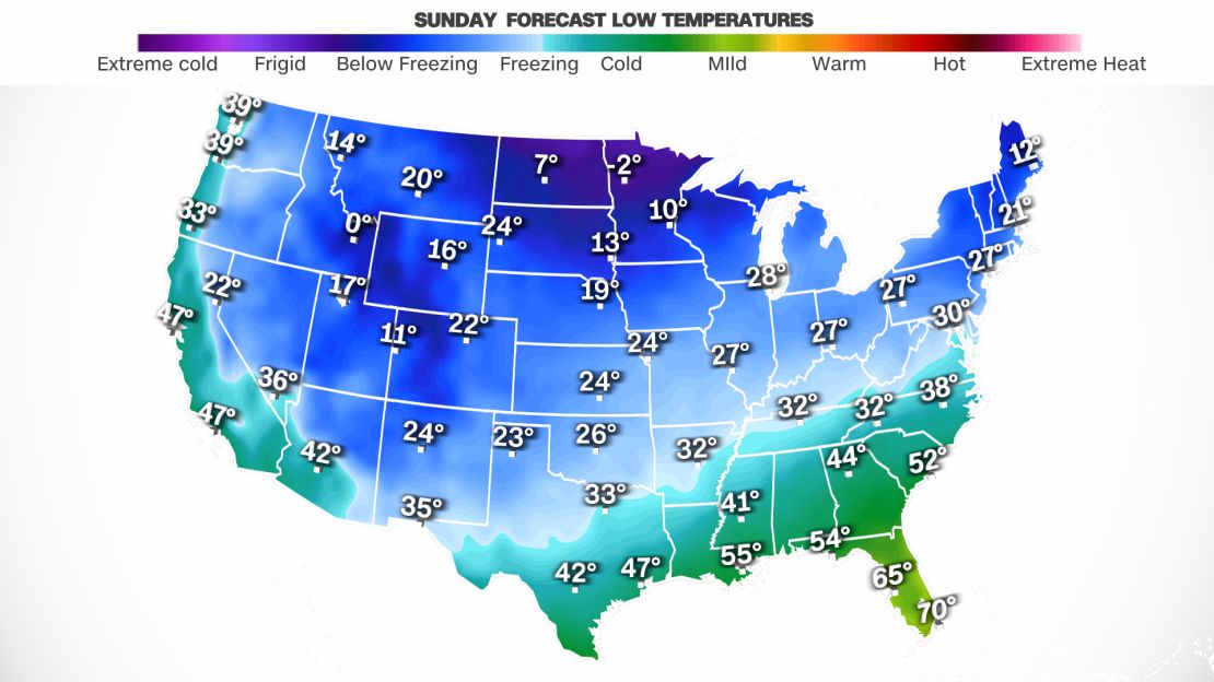
For some, it may still feel 10 to 20 degrees above average today, maybe even tomorrow. But cold air will take over and about 70% of the US population will feel temperatures drop below freezing by the end of the week.
This will create hazards where some people will experience snow measured with yardsticks, while some could see blizzard conditions so cold it will deliver frostbite in minutes. In contrast, others could see flooding rains and severe storms capable of producing tornadoes.
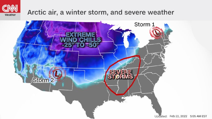
This dangerous weather is commencing because two extremely warm and cold air masses are colliding.
The coldest air will remain bottled up in the central and western states where temperatures will be 20 to 45 degrees below average for the next couple of days. Some places in the Northern Plains will have high temperatures Tuesday that never get above zero degrees Fahrenheit. Grand Forks, North Dakota, will actually stay below zero until Friday, CNN meteorologist Brandon Miller said.
Sign up to get forecast and weather news from our meteorologists in your inbox
This arctic air mass will slowly dip south and east.
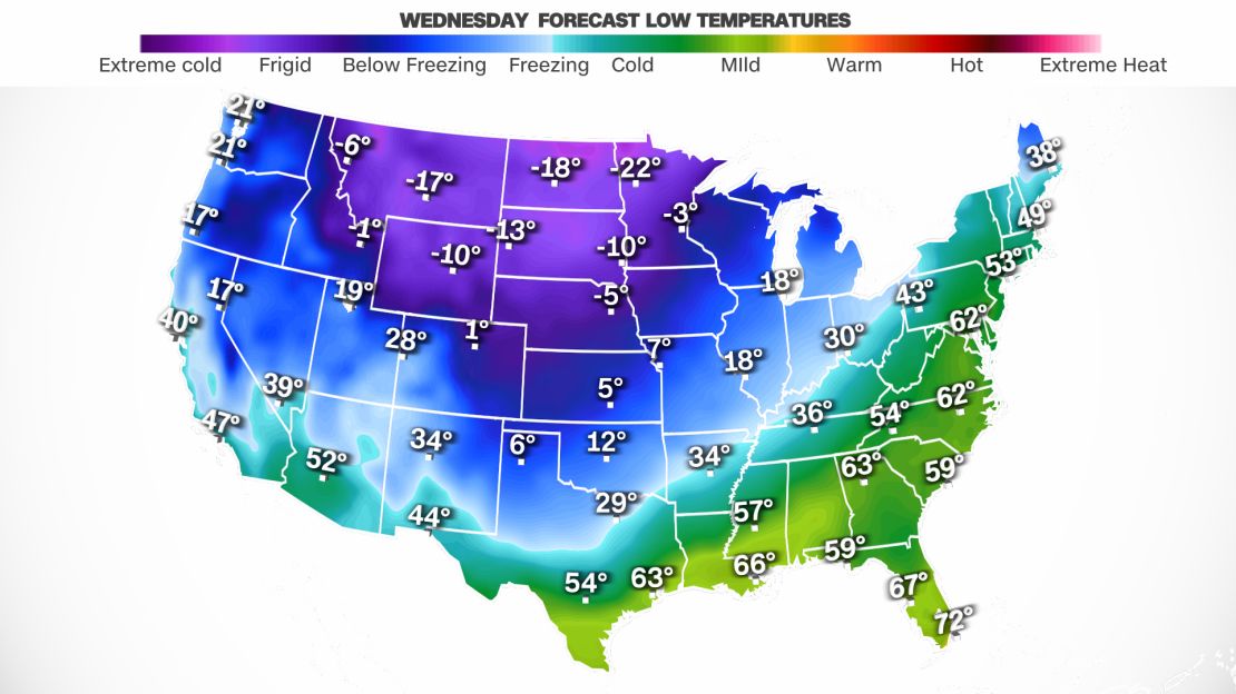
The difference in temperature extremes is so great over such a short distance, the highs on Wednesday will be 36 in Dallas and 76 in Houston, a difference of 40 degrees of just over 200 miles.
“When brutally cold Arctic air and spring-like warm air clash, bad things happen,” CNN meteorologist Chad Myers said. “We will see a snow and ice storm to the north and severe storms in the South.”
And not just one storm; multiple storms will move along this boundary of cold and warm air over the next few days.
Tuesday’s storm is bringing blizzard conditions that could lead to frostbite in minutes
Snow is already falling across the Northern Plains and another half a foot could fall through Tuesday afternoon. What will make the situation even more dire than a fresh coat of snow will be the strong winds.
Blizzard warnings are in effect across portions of the Plains where winds up to 40 mph are whipping around snow, reducing visibility and creating dangerous wind chills.
“The dangerously cold wind chills as low as 45 below zero could cause frostbite on exposed skin in as little as 10 minutes,” the National Weather Service in Aberdeen, South Dakota, wrote.
Check when your town is likely to dip below freezing
This storm system will move east through Tuesday night but not everything from the sky will fall as snow.
“Periods of sleet and freezing rain will lift across Wisconsin and Michigan through Tuesday evening,” the Weather Prediction Center (WPC) said.
Significant ice accumulation exceeding one-quarter inch is possible across this region “which will create hazardous travel and isolated power outages,” the WPC said.
This hazardous ice and sleet storm then progresses into northern New England through the evening hours Tuesday.
Flooding rain and possible tornadoes Tuesday
Excessive rainfall along with severe thunderstorms are expected on the warmer side of the clash of air masses from Mississippi to New York.
“Scattered to widespread thunderstorms will spread across the Lower Mississippi Valley, Tennessee/Ohio Valleys and into the Northeast,” the WPC said.
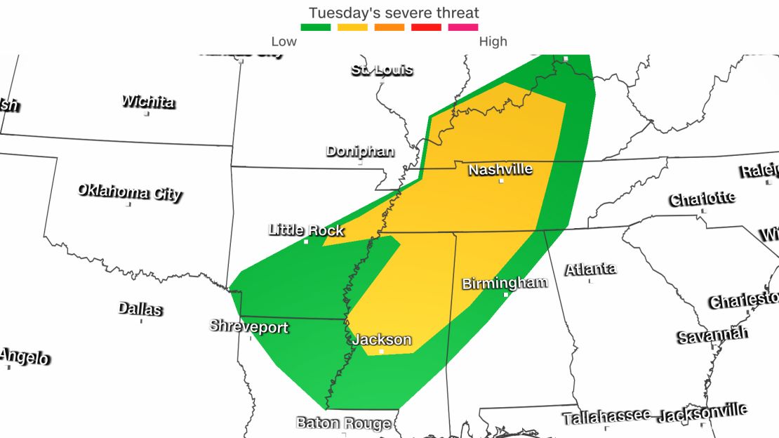
This area has a slight risk – level 2 of 5 – for severe storms Tuesday, with the threat of damaging winds, a few tornadoes and isolated severe hail, warned the Storm Prediction Center.
“The associated heavy rain will create numerous areas of flash flooding. Furthermore, many streams may flood, potentially affecting larger rivers through Wednesday morning,” the WPC said.
Some Southern states could see 3 to 4 inches of rainfall Tuesday. A moderate risk – level 3 of 4 – for excessive rainfall has been forecast for portions of northern Alabama and Mississippi through much of western Tennessee and into southern Kentucky.
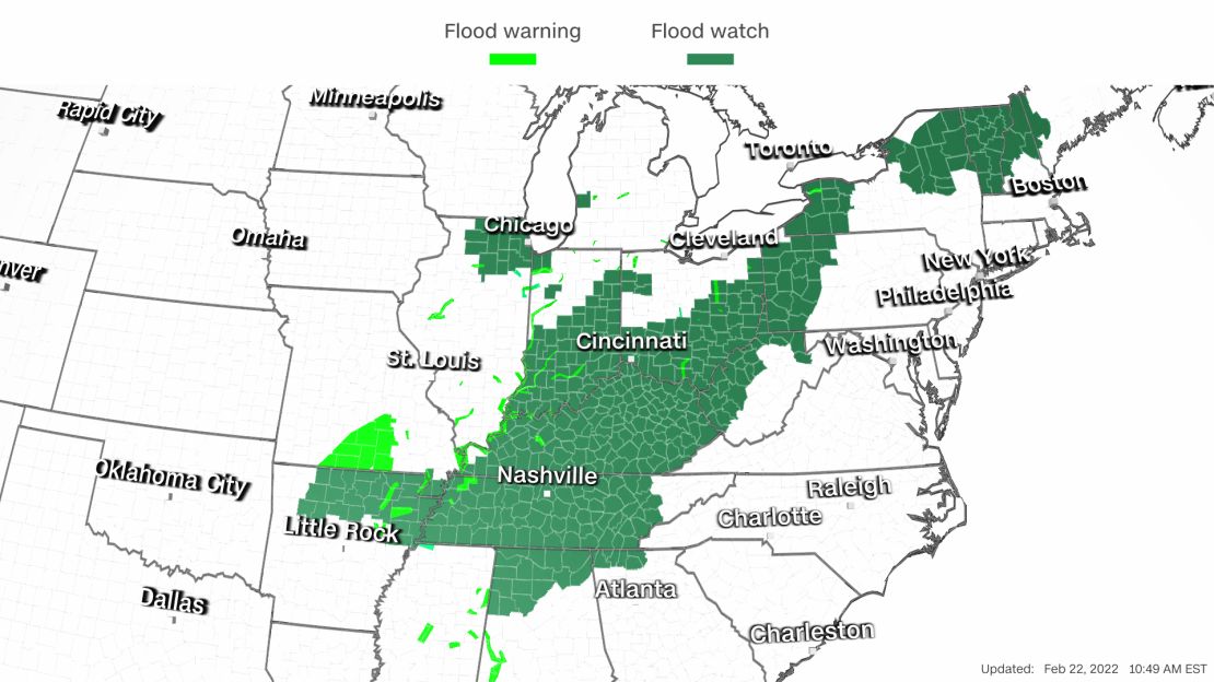
And a broader slight risk – level 2 of 4 – for excessive rainfall stretches from central Mississippi to southern Indiana and eastward to the Appalachians.
More than 40 million people in this region are under flood watches Tuesday.
3 to 4 feet of snow is possible
The next winter storm is taking shape in the West. It is dipping south across California before moving east.
“The system will produce rain and higher elevation snow over parts of the Northwest and Northern/Central California,” the WPC said.
“The low system is the coldest we’ve seen so far this season,” the National Weather Service (NWS) office in Los Angeles said, “but is also moisture-starved due to the limited fetch over the ocean.”
This means the rain and snow amounts will likely stay lower in this region. Rain is likely at the lowest elevations, but with the colder temperatures, snow – by tonight – could fall as low as 1,500 feet in elevation across the mountains.
“Snow will move into the Southwest and Central Rockies overnight Tuesday into Wednesday morning,” the WPC said.
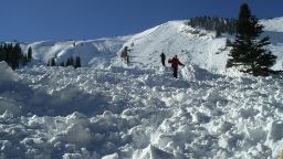
Total snow accumulations could be one to two feet, with three to four feet over favored highest terrain, said the NWS in Grand Junction, Colorado. This forecast includes mountain towns like Aspen and Vail, Colorado. The weather service also warned of winds gusting as high as 45 mph.
With this much snow and with these winds, avalanche danger is considerable this week.
Avalanche conditions can also be considerably worse when a big snow storm falls after a month of weaker systems.
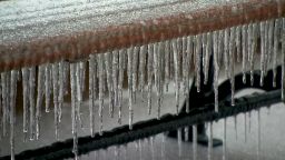
Damaging ice storm develops
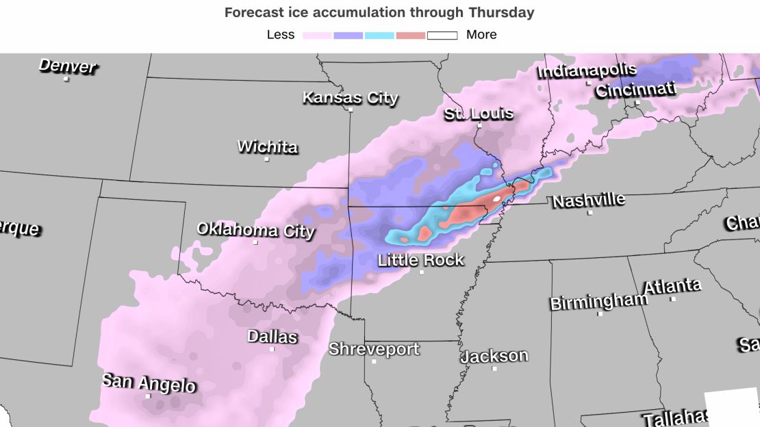
Energy from this storm will move into the Southern Plains on Wednesday, setting the stage for a dangerous ice storm.
“Freezing rain and sleet are forecast to expand over the Southern Plains and Middle Mississippi Valley starting Wednesday and continue into the Ohio Valley Thursday,” the WPC said. “Significant ice accumulations are likely, with damaging ice possible in the Ozarks.”
Some locations will see sleet – maybe even some snow – while others may see more freezing rain.
This wave of wintry weather is possible from Oklahoma City through Fayetteville, Arkansas, and to Louisville, Kentucky.
“Hazardous travel conditions and impacts to infrastructure are becoming more likely,” the WPC said. The details in the track and timing of the storm and precipitation type and amounts remain uncertain, it added.
This storm will continue to track into the East late week, possibly bringing some snow to major cities in the Northeast.
Those in the East can count on the warmer-than-average temperatures to take a dive by week’s end, no matter what precipitation may come.